
Hidalgo County, New Mexico, USA
Eagle Point Tungsten Project
Ownership: 100%
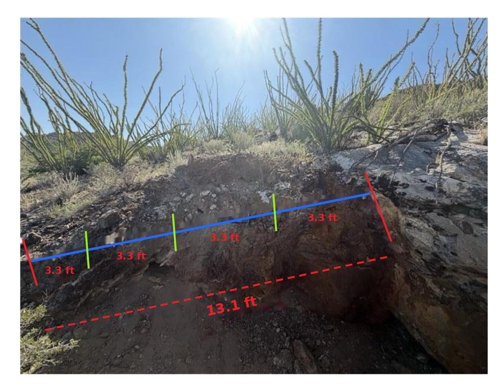
Channel CH1 outcrop, Eagle Point. Source: company news release, October 7, 2026
Summary
A past-producing tungsten project where scheelite-bearing skarn occurs along the contact between Horquilla Limestone and intrusive granite. Tungsten mineralization has been recognized here since the early 1940s.
Where it stands
- August 2026 field program complete: geological mapping, 23 analytical samples including four one-metre channel intervals.
- October 7, 2026: first modern assays. Channel CH1 returned 0.11% WO₃ over 13.1 feet (estimated true width approx. 12.5 feet), including 0.18% WO₃ over 3.3 feet. Grab samples returned up to 0.55% WO₃. 14 of 23 surface samples exceeded 0.10% WO₃ and 21 of 23 exceeded 100 ppm W. Scheelite-bearing skarn has been mapped intermittently along approx. 2,600 feet of the limestone-granite contact.
- November 11, 2026: a drone magnetic survey over about 4.9 km² traced the interpreted granite-limestone contact that hosts the skarn for about 3 km, extending north-west beneath shallow cover. The planned 17-hole program is positioned on that contact, with six holes stepping out up to about 400 metres north-west of the historical workings. Interpretation by Warren Hughes, P.Geo. (East Coast Consulting); technical information in that release reviewed and approved by Jasper Mowatt, MIMMM, MAusIMM, a QP who is not independent of the Company.
- Updated 3D geological model built in Leapfrog Geo.
- Planned 17-hole drill program of approximately 1,850 metres (6,070 feet) to test the skarn at depth.
- September 2026: fourteen new lode claims cover the western extension of the skarn system, and a surface agreement provides exclusive surface-use rights over about 640 acres for an initial five-year term, with renewal options for up to 25 years (company news release, September 15, 2026).
Next stepsOctober 2026: exploration notice submitted to BLM and the drill contract tendered. State permits and BLM review remain prerequisites.
Grab samples are selective by nature and may not be representative of mineralization on the property. Technical information reviewed and approved by Jacob Anderson, CPG, MAusIMM, an independent Qualified Person under NI 43-101. Source: company news release, October 7, 2026.
Federal exploration record
History
- 1940-41
Tungsten discovered at Eagle Point; first claims staked in 1941.
- 1941-1957
Examined repeatedly by U.S. Bureau of Mines and U.S. Geological Survey geologists; the subject of four federal exploration-assistance applications (DMA-1475, DMA-1476X, DMEA-3276, DMEA-3701).
- 1943-44
About 650 to 665 short tons grading about 0.44% WO₃ mined from an open cut and shipped (Faick and MacKallor, 1951; Dale and McKinney, 1959).
- 1954
215 feet of trenching; government examiners estimated a historical mineralized system on the order of 170,000 tons (about 70,000 tons at 0.40% WO₃ and 100,000 tons at 0.25% WO₃).
- 1955
The U.S. Government signed a Defense Minerals Exploration Administration contract (Idm-E-783, Docket DMEA-3701) to fund 75% of shaft sinking and diamond drilling. It was never carried out.
- 1957
Last recorded work on the property.
- 2026
Western Star acquires the project (June 15), maps scheelite-bearing skarn along about 2,600 feet of contact, reports first modern assays (October 7), submits an Exploration Notice to the BLM (October 22) and maps the skarn contact beneath cover with drone magnetics (November 11).
The historical production figures and the 1954 estimate pre-date modern reporting standards, have not been verified by a Qualified Person and are not current mineral resources or reserves. The Company is not treating them as current and provides them for historical context only. Sources: company news releases of June 15, August 12 and October 7, 2026.
Project Details
- Access
- Road accessible; State Highway 81 within 4 miles; exploration can be conducted year-round; BLM-administered mineral claims. Source: company news release, June 15, 2026.